|

JEBEL SUMAYNI Facts:
- AKA: - Jebel Sumayni is also known as Jebel Sumeini.
- Altitude: - 1073 metres campsite is approx 420 metres.
- Round-trip: - Give yourself about 6-7 hours. This includes
plenty of stops, and an hour for lunch on the summit. If you
are short of time you can easily reduce this.
- Difficulty: - A mixture of uphill walking on rocky
paths, and scrambling up wadi beds. There is little or no exposure,
but some of the wadi beds are quite steep and loose, and require
care to avoid slipping. These present more of a problem during
the descent, but should be no trouble if you take your time.
- Liz fear factor: - 2/10 No scary bits unless you go
off-piste!!
- Chirri dog factor: - Easy, I don't need any help climbing,
but it's a long day, and my paws can get a bit sore on the sharp
rocks if I don't wear my boots. Plenty of animal tracks and
scents to follow. No goat or donkeys to chase, although I do
imagine that I see a few. No pools of water to drink at, and
not many boulders to shade under.
- Dangers: - Take care descending because some of the
wadi beds are steep and loose. Take plenty of water as you work
hard on the climb and lose a lot of fluid.
- Wildlife and plants: - A lot to interest botanists
and birders. The Crag Martins which patrol the summit
cliffs put on a great arial display.
- Geology: - Look out for the interesting sedimentary
formations round the corner from the campsite and on the climb
up the wadi to the first col.
- Local History: - The tomb-like mound near the summit
is a wolf / fox trap.
- Guest Book: - There is a Guest Book buried in the summit cairn. Leave
your comments and thoughts, and read those left by others.
Here is the guest book as it was on 23 Jan 2010.
Guest Book - PDF
- Navigation: - See waypoints and route links below
(All
positions are given as UTM coordinates at WGS84 Datum; most modern
consumer GPS receivers can handle this.)
Introduction
Jebel Sumayni (or Sumeini) is a mountain on the
UAE - Oman border. It's my favourite mountain in these parts. There are many reasons for this; the rock
is great, the climb is interesting and the rewards on the summit,
in terms of views, make it difficult to drag yourself away for
the descent. The camp-site is very attractive and even if you
aren't up to climbing to the summit, a short excursion up to the
first col or beyond is well worth doing.
The
following description should enable you to find the camp and climb
the mountain. Several people have used my directions successfully,
but be warned that I've deliberately limited the amount of detail
in the climbing route to key landmarks so you can still have a
bit of fun finding your own route between these.
At
1073m, Jebel Sumayni rises to the east of the gravel plains of Wadi
Sumayni. The summit, although
visible from the village of Shuwaib,
is best approached from its eastern flanks in Wadi
Mayhah. The climb starts near the
small settlement of Tawi Junaynah,
with its lush plantations, and smart whitewashed houses. Tawi
Junaynah can be reached from
the north via a track starting near Jebel
Rowdah on the Al Madam to Hatta
road. There is also easy access from the village of Shuwaib.
A
track leading north from Tawi
Sumayni up Wadi Qutayt would take you very close to the western flanks
of the Jebel and very close to
the summit but from there the cliffs are steep and the rock very
loose. Starting the climb from the other side makes for a much
more interesting hike, even though it's far less direct, being
a distance of over 3 km to the summit 'as the crow flies'.
Once you overcome the initial rocky gullies the mountain mass
opens out in all its glory. Most of the steeper climbing is done
early on and there is a great sense of openness and easy climbing
up high.
Climbing
Jebel Sumayni isn't difficult. There are only a few places
where you need to use your hands to climb, and there is very little
exposure. From the start of the climb the actual summit is a fair
way back so be prepared for false summits!
At
a gentle pace, the climb to the top should take less than three
and a half hours, including time for rests and to admire the superb
views on the way up. You can easily spend up to an hour on the
top taking photos, having a drink and snacks. The journey down
is quite straightforward now that you know the route; again it's
wise to pick up the donkey tracks to make the going easier. There
are alternative ways down, but generally, I wouldn't recommend
taking unfamiliar routes down a mountain because it's all too
easy to unwittingly get yourself into tricky rock climbing situations.
The descent should take around two and a half to three hours with
stops so plan on a maximum of seven hours for the round trip.
Take your time on the way down. Your legs will be tired and the
rocks are sharp, as I learned to my cost.
1. To the base - camp
From the Al Madam - Hatta Road.
Turn at the roundabout near the petrol station on the surfaced road, going south opposite Jebel
Rowdah to Tawi
Junaynah in about 15 km. This
goes via Wadi Khudayrah,
Wadi Khadra and the pools near Shuwayhiyin.
This would be the best approach if you were coming from Dubai or
the Northern Emirates and is very straightforward.
From Al-Ain
Cross through the Hili check point into Buraimi, and then onto the road to Sohar. Turn left towards Mahdah on the roundabout just past the Buraimi Hotel. Go via Fossil Valley, Wadi Sharm, Jebel Ghawil, and the junction at wadi Sumeini to Tawi Junaynah.
To
the camp site (UTM 40R 391,749E 2,734,388N) from Tawi Junaynah
From
the plantation at Tawi Junaynah look west towards the mountains. There is a wide
flat, gravel plain before you. From the small settlement, you have
to cross the plain and enter one of the wadis opposite. There are two main tracks across this
plain. The one, which leads directly to the wadi,
starts at the northern end of the settlement at a steep track out
of a shallow wadi bed.
Head
across the plain on the bumpy track and enter the wadi (UTM 40R 392,257 2,735,318N). Here there is a tree at a road junction.
Continue into the wadi passing the two small farmsteads, one with a camel,
and the other with goats. From here the track deteriorates, but
is easily navigable by 4WD vehicle. Eventually this track leads
to a small solitary hill only a few meters high. In the vicinity
are a number of flat areas suitable for camping. If you cross from
here towards the mountain you may find some cleared areas from previous
camps; using these limits any environmental damage to this largely
unspoiled site.
Via
Shuwaib (now no longer possible due to a border fence)
If
coming from Abu Dhabi, take the road via Sweihan,
and Al Hayer to the village
of Shuwaib. There is now a new town at Shuwaib
but you need to make for the old town, which is reached by taking
the first turnoff (downhill) from the small roundabout with the
petrol station to one side. The other exit from this roundabout
leads to Al Madam and Al Dhaid.
To
the gravel plain
(now no longer possible due to a border fence)
A
short distance down the hill from the petrol station you come to
a cattle grid (UTM 40R 379,541E 2,737,315N), and you should turn
right just past here. Look over towards the dunes and you should
see a 'gatch' track leading up
into the sand. Take this track on a very pleasant easy drive through
the dunes until you reach the gravel plain, which separates you
from the range of mountains in the distance. You shouldn't need
to deflate your tires at all, although 4WD may be necessary when
crossing the gravel plain.
To
the Omani checkpoint (UTM 40R 388,749E 2,728,643N) (now no longer possible due to a border fence)
As
you leave the dunes by a small farm enclosure (UTM 40R 381,214E
2,735,692N), you are presented with a wide selection of tracks.
You need to choose one that will take you across the plain towards
the mountains, and then into the gap where there is an Omani checkpoint.
The best direction is approximately southeast. Along the base of
the hills there is a good graded track, which you will eventually
join. Aim for (UTM 40R 384,055E 2,733,233N). This track goes directly
past the checkpoint so when you join it you just have to turn right
in order to take you to the checkpoint in about 7 kilometers.
To
the road junction (UTM 40R 396,294E 2,726,280N) (now no longer possible due to a border fence)
Go
through the checkpoint (you may need to show ID), and head on through
the gap in the mountains. Soon you'll come across a large valley
to the left, with a plantation at its entrance. If you look up this
valley you'll see Jebel Sumayni, rising up on the right (east) side. Here you need
to continue on the main track because the climb goes up the other
side of the mountain. Be thankful! Continue on the main graded track
until you come to a definite junction with blue signs. Turn left
here (NW) to Hadf and Hatta
(signposted Hadf).
To
the plantation (UTM 40R 393,604 2,736,000N) (now no longer possible due to a border fence)
Continue
for roughly 12km kilometers until you reach a plantation. On your
left is a white building, with a patio, right next to the road.
Turn left here.
2.
The Reconnaissance and Climb
If
you arrive early enough you may like to do a bit of reconnaissance,
to save time on the actual climb, and give you a taste of what's
to come. You could also take up some water and stash it to save
carrying it up next day. In an hour and a half you can easily get
to the first col, do a bit of exploration and route finding, take
some photos in the evening light, and return to the camp-site ready
to do justice to a hearty BBQ.
To
the first col
From
the campsite, head to the main wadi keeping the rocky slopes to your left. The track
curves around to the left into the wadi.
The watercourse should be on your right and you should be heading
directly towards the mountain mass. Keep to the left side following
the donkey tracks, and after about ten minutes the track will curve
left (South) into a small rocky wadi
with steep cliffs to the left and a shallower rocky slope to the
right. The path soon peters out and you are forced to cross to the
right hand side. The aim is to make your way up this wadi until you reach a small col at the top. It is
best to travel high on the right hand bank of the wadi,
rather than stumble along its bed. There are many donkey tracks
all over this mountain and they make the going much easier if you
can find one going in your general direction. While climbing you
should look over to the steep cliffs on the left hand side to see
some unusual brown, green, and purple rock formations. The cliffs
are like puff pastry and crumble into tiny rectangular fragments
giving a granular appearance to the hillside. If you are here during
the afternoon, the cliffs should be well lit by the sun to show
off the unusual colours.
After
about 30 minutes from the camp you'll reach the col, which is an
interesting crossroads with a small well-constructed cairn. If you
were to continue straight on, you would descend into another valley
system to the south. To the east is a short path leading to a notch
in the ridge with a small tree. Here it may be possible to scramble
down to the campsite offering an alternative route on your return.
To
the gully
To
the West towards the main mountain is the way to go, but before
you leave the col, take a good look at the gullies going up the
mountain to determine which one to make for. The slope rising up
nearest to you is an ill-defined wide chute. To the left of this
is a small well defined gully, and to the left of that is a much
deeper wider gully. Both of these two head straight up to the skyline,
but it is the first small gully, which you should aim for. It joins
the larger gully near the top, and it offers better footing. Between
you and the gullies is a boulder field and if you look straight
towards the mountain from the col, and slightly to the left, you
should see a prominent boulder the size of a people-carrier and
a fair bit larger than the rest. If you head for this by first going
towards the mountain and then angling to the left, you should be
able to pick up a donkey traverse. This passes the boulder, crosses
a small watercourse onto a spur, and then traverses around the right
shoulder of the small gully to drop you down into it about ten meters
or so up from the mouth. If you miss this route then not to worry,
you can just make your own way over to the entrance to the gully.
It should only take ten to fifteen minutes to get there from the
col.

Click
on globe for a route diagram
To
the second col
Start
climbing fairly steeply up the loose rocks of the gully until you
reach a vertical rock wall across it. This is about three meters
high, and presumably makes an attractive waterfall when it rains
on the mountain. You can attack the wall direct if you fancy a rock-climb, or easily bypass it to the left or right. From
the top of the wall is a nice place to stop for a rest and to admire
the view back down to the gravel plain, and the mountains beyond.
Looking up the mountain you can see that your gully is about to
end and from the wall you should climb up and head over to the left
side where you can easily get on to the left shoulder near the top.
From the shoulder you can look down left into the next deeper gully
which you saw from the col. Looking up this deep gully you can see
another larger rock wall which would offer some interesting scrambling,
but this can be avoided by keeping to the shoulder, now to the right
of the big gully, and making your way towards and around the right
side of car sized boulder. From here you can traverse up and across
to the left so that you stay on the right hand shoulder of the main
gully. The gradient starts to ease a little and you will reach a
spacious col paved with more tiny rock fragments. Here there are
views down into a valley system to the west.
To
the bowl
To
the south you will see a gully rising up away from you. This is
in fact a continuation of the large gully, which you've just followed
up, and leads left from the top of that gully. From the col you
should make out a donkey trail leading from the col and along the
gentle slopes of the gully's right side. The trail soon leads down
to the left and into the bottom of the gully where it crosses over
to the left hand side and then steeply up a groove onto the shoulder
where you can make good progress until being forced back into the
gully again. In any case, just work your way up the gully keeping
to the left side until you reach another col with views down to
the east. Here, to the right is an entrance into a bowl. Enter the
bowl and keep climbing up the left side of the bowl with a ridge
on your left and in a few minutes you will top out on a ridge running
to the right. Over the other side of this ridge you can look steeply
down into yet another valley. Continue along this ridge and start
a short climb to the top of another ridge from which you get your
first clear view of Jebel Sumayni. There are three peeks ahead. The left hand
one is rather jagged but the other two are gently rounded and appear
smooth. Jebel Sumayni is the
middle peak and you should be able to make out its summit cairn
and also a marker on the hill to its right.
Click on
globe for a route diagram
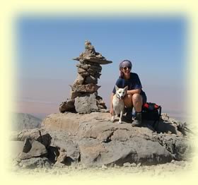
To
the summit (UTM 40R 390,613E 2,732,343N) 1077m
 If
you walk directly towards your goal you'll start to descend to a
pleasant col with a couple of lonely trees. The descent is fairly
easy but it hurts to lose some of your hard earned altitude, especially
when you realise that you'll need to climb
this hill again on your way back! Before you descend to the trees,
take a good look at your destination and try to remember features
to make your final ascent up the Jebel as easy as possible. It all looks very different
from the trees at the col. From there it shouldn't take much more
than twenty minutes to reach the summit. On the way up there is
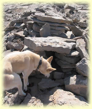
an easy path along a rock fault which leads you neatly to a man
made structure built in the shape of a tomb, and constructed from
the natural tile-shaped rocks scattered around. I wonder who built
it and why. It doesn't look very old but someone has gone to a lot
of effort to build it. Anyway, it makes a very comfortable seat
with a wonderful view to the east. From here it is an easy stroll
over to the rather precarious looking summit cairn. The cairn provides
some welcome shade but you feel it might come
tumbling down on top of you at any minute. Looking down the steep
cliffs in the valley to the west you see a wadi with a vehicle track. This leads back down to the south to the plantation,
which you may have passed shortly after the Omani checkpoint, if
you came that way. Climbing the Jebel
from this side looks more direct but is a lot steeper and much more
difficult. On a clear day, there are great views all around; you
can probably make out the swirl of Jebel
Rowda to the North and Jebel
Hatta to the east. The views to
the west show the deep red dunes contrasted against the grey of
the gravel plains and the mountains. If
you walk directly towards your goal you'll start to descend to a
pleasant col with a couple of lonely trees. The descent is fairly
easy but it hurts to lose some of your hard earned altitude, especially
when you realise that you'll need to climb
this hill again on your way back! Before you descend to the trees,
take a good look at your destination and try to remember features
to make your final ascent up the Jebel as easy as possible. It all looks very different
from the trees at the col. From there it shouldn't take much more
than twenty minutes to reach the summit. On the way up there is
an easy path along a rock fault which leads you neatly to a man
made structure built in the shape of a tomb, and constructed from
the natural tile-shaped rocks scattered around. I wonder who built
it and why. It doesn't look very old but someone has gone to a lot
of effort to build it. Anyway, it makes a very comfortable seat
with a wonderful view to the east. From here it is an easy stroll
over to the rather precarious looking summit cairn. The cairn provides
some welcome shade but you feel it might come
tumbling down on top of you at any minute. Looking down the steep
cliffs in the valley to the west you see a wadi with a vehicle track. This leads back down to the south to the plantation,
which you may have passed shortly after the Omani checkpoint, if
you came that way. Climbing the Jebel
from this side looks more direct but is a lot steeper and much more
difficult. On a clear day, there are great views all around; you
can probably make out the swirl of Jebel
Rowda to the North and Jebel
Hatta to the east. The views to
the west show the deep red dunes contrasted against the grey of
the gravel plains and the mountains.
This is the most popular route up the mountain, but as always there are many ways up. I'll leave it for you to discover them when you are feeling adventurous!
If you find a new way up, that you think I may be unaware of, please let me know. I'm always interested!
Roy L Richards, November
2001 updated 2010
Footnote:
The tomb-like structure is probably an animal trap, and the precarious
summit cairn is no longer precarious because it was knocked over,
and has since been rebuilt in a smaller reincarnation.
ver: Jan 2010 - Updated to account for border fence, and to mention guest-book.
© Roy L Richards 2012
Contact for problems, queries etc:
|
Updated Jan 2010
|
|

|
|
|
|

|
|
|


